Downloading and Exporting Data
From the dataset detail page, it is possible to download data in several output formats if you have the permissions to do so. The conversion will be performed automatically by GeoNode through the OGC Protocols.
Move to the
MainrddatasetClick on the
Downloadfrom the menu.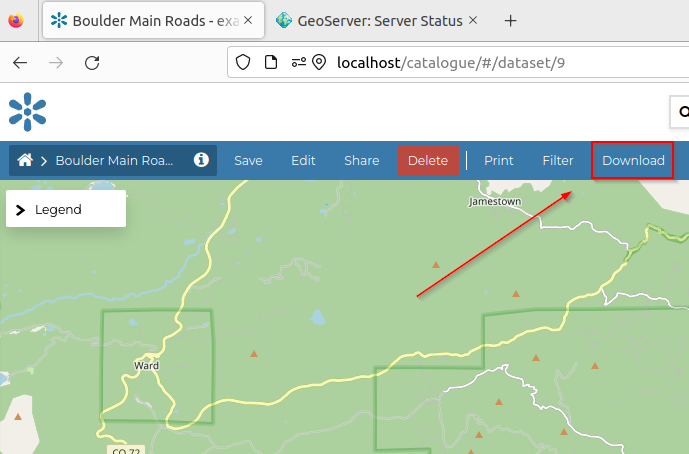
It will show the
Export Datawindow with several options and choices of the files format.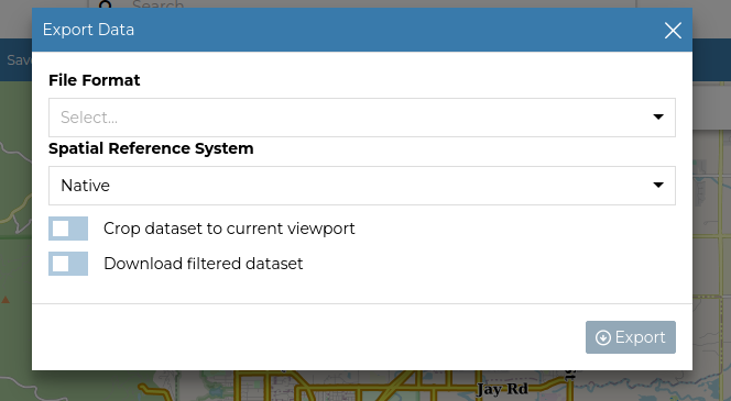
Downloading the whole dataset
From the Export Data window, select a file format and click Export.
Obtaining a filtered subset
This option is valid only for VECTORIAL datasets.
From the
Export Datawindow, you can turn on theDownload filtered datasetoption as shown below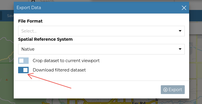
The above will download the dataset with filters set from the
Filterwindow below.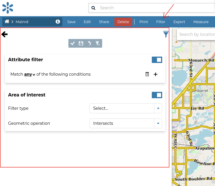
First of all select the type of logic operator,
All == AND,Any == OR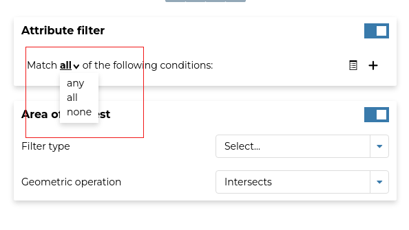
Click on the
+button to add the condition to the filter. Select the logic operator to match the value, e.g.LIKEmeanscontainsNext, select the attribute you want to use to filter the subset
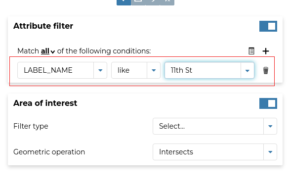
Click on the
+button to add another condition to the filter; notice how the selected condition will be listed belowBy default the
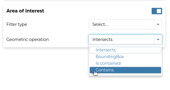
Area of Interestis on. You specify the filter byFilter typeandGeometric operationor turn it off if you don’t wish to set those filters.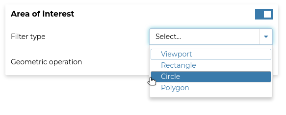
Click on the  icon to apply and see changes on the map.
If everything looks fine, click on the icon ![]() to save changes.
to save changes.
If you select the
File formatyou want in theExport Datawindow, the results to; e.g. by selectingGeoJSONyou will get the following results from the above example{ "type": "FeatureCollection", "features": [ { "type": "Feature", "id": "Mainrd.59", "geometry": { "type": "MultiLineString", "coordinates": [ [ [ 3062088.181, 1249165.789 ], [ 3062451.08, 1249272.489 ] ] ] }, "geometry_name": "the_geom", "properties": { "fid": 59, "LABEL_NAME": "Walnut St" } }, { "type": "Feature", "id": "Mainrd.61", "geometry": { "type": "MultiLineString", "coordinates": [ [ [ 3061723.714, 1249069.253 ], [ 3062088.181, 1249165.789 ] ] ] }, "geometry_name": "the_geom", "properties": { "fid": 61, "LABEL_NAME": "Walnut St" } }, { "type": "Feature", "id": "Mainrd.86", "geometry": { "type": "MultiLineString", "coordinates": [ [ [ 3061355.12, 1248969.761 ], [ 3061723.714, 1249069.253 ] ] ] }, "geometry_name": "the_geom", "properties": { "fid": 86, "LABEL_NAME": "Walnut St" } }, { "type": "Feature", "id": "Mainrd.88", "geometry": { "type": "MultiLineString", "coordinates": [ [ [ 3062451.08, 1249272.489 ], [ 3062824.349, 1249369.35 ] ] ] }, "geometry_name": "the_geom", "properties": { "fid": 88, "LABEL_NAME": "Walnut St" } }, { "type": "Feature", "id": "Mainrd.140", "geometry": { "type": "MultiLineString", "coordinates": [ [ [ 3059898.114, 1248600.093 ], [ 3059912.48, 1248594.44 ], [ 3059941.91, 1248593.56 ], [ 3060145.13, 1248645.4 ], [ 3060250.16, 1248676.419 ] ] ] }, "geometry_name": "the_geom", "properties": { "fid": 140, "LABEL_NAME": "Walnut St" } }, { "type": "Feature", "id": "Mainrd.229", "geometry": { "type": "MultiLineString", "coordinates": [ [ [ 3060987.191, 1248873.845 ], [ 3061355.12, 1248969.761 ] ] ] }, "geometry_name": "the_geom", "properties": { "fid": 229, "LABEL_NAME": "Walnut St" } }, { "type": "Feature", "id": "Mainrd.255", "geometry": { "type": "MultiLineString", "coordinates": [ [ [ 3060619.651, 1248775.923 ], [ 3060987.191, 1248873.845 ] ] ] }, "geometry_name": "the_geom", "properties": { "fid": 255, "LABEL_NAME": "Walnut St" } }, { "type": "Feature", "id": "Mainrd.321", "geometry": { "type": "MultiLineString", "coordinates": [ [ [ 3060250.16, 1248676.419 ], [ 3060619.651, 1248775.923 ] ] ] }, "geometry_name": "the_geom", "properties": { "fid": 321, "LABEL_NAME": "Walnut St" } }, { "type": "Feature", "id": "Mainrd.527", "geometry": { "type": "MultiLineString", "coordinates": [ [ [ 3063555.141, 1249566.88 ], [ 3063930.22, 1249668.529 ] ] ] }, "geometry_name": "the_geom", "properties": { "fid": 527, "LABEL_NAME": "Walnut St" } }, { "type": "Feature", "id": "Mainrd.579", "geometry": { "type": "MultiLineString", "coordinates": [ [ [ 3064612.55, 1249853.859 ], [ 3064809.989, 1249906.62 ] ] ] }, "geometry_name": "the_geom", "properties": { "fid": 579, "LABEL_NAME": "Walnut St" } }, { "type": "Feature", "id": "Mainrd.632", "geometry": { "type": "MultiLineString", "coordinates": [ [ [ 3061252.3, 1249341.19 ], [ 3061201.959, 1249524.828 ] ] ] }, "geometry_name": "the_geom", "properties": { "fid": 632, "LABEL_NAME": "11th St" } }, { "type": "Feature", "id": "Mainrd.633", "geometry": { "type": "MultiLineString", "coordinates": [ [ [ 3065453.729, 1250103.404 ], [ 3065760.373, 1250187.36 ] ] ] }, "geometry_name": "the_geom", "properties": { "fid": 633, "LABEL_NAME": "Walnut St" } }, { "type": "Feature", "id": "Mainrd.704", "geometry": { "type": "MultiLineString", "coordinates": [ [ [ 3064294.881, 1249767.116 ], [ 3064317.058, 1249773.172 ], [ 3064612.55, 1249853.859 ] ] ] }, "geometry_name": "the_geom", "properties": { "fid": 704, "LABEL_NAME": "Walnut St" } }, { "type": "Feature", "id": "Mainrd.720", "geometry": { "type": "MultiLineString", "coordinates": [ [ [ 3063192.21, 1249469.411 ], [ 3063555.141, 1249566.88 ] ] ] }, "geometry_name": "the_geom", "properties": { "fid": 720, "LABEL_NAME": "Walnut St" } }, { "type": "Feature", "id": "Mainrd.779", "geometry": { "type": "MultiLineString", "coordinates": [ [ [ 3066127.684, 1250290.216 ], [ 3066254.58, 1250325.75 ], [ 3066333.921, 1250344.23 ] ] ] }, "geometry_name": "the_geom", "properties": { "fid": 779, "LABEL_NAME": "Walnut St" } }, { "type": "Feature", "id": "Mainrd.811", "geometry": { "type": "MultiLineString", "coordinates": [ [ [ 3061355.12, 1248969.761 ], [ 3061303.024, 1249159.043 ] ] ] }, "geometry_name": "the_geom", "properties": { "fid": 811, "LABEL_NAME": "11th St" } }, { "type": "Feature", "id": "Mainrd.841", "geometry": { "type": "MultiLineString", "coordinates": [ [ [ 3065397.156, 1250087.79 ], [ 3065453.729, 1250103.404 ] ] ] }, "geometry_name": "the_geom", "properties": { "fid": 841, "LABEL_NAME": "Walnut St" } }, { "type": "Feature", "id": "Mainrd.879", "geometry": { "type": "MultiLineString", "coordinates": [ [ [ 3063930.22, 1249668.529 ], [ 3064294.881, 1249767.116 ] ] ] }, "geometry_name": "the_geom", "properties": { "fid": 879, "LABEL_NAME": "Walnut St" } }, { "type": "Feature", "id": "Mainrd.988", "geometry": { "type": "MultiLineString", "coordinates": [ [ [ 3064809.989, 1249906.62 ], [ 3064945.19, 1249942.75 ], [ 3065017.521, 1249974.065 ] ] ] }, "geometry_name": "the_geom", "properties": { "fid": 988, "LABEL_NAME": "Walnut St" } }, { "type": "Feature", "id": "Mainrd.1223", "geometry": { "type": "MultiLineString", "coordinates": [ [ [ 3062824.349, 1249369.35 ], [ 3063192.21, 1249469.411 ] ] ] }, "geometry_name": "the_geom", "properties": { "fid": 1223, "LABEL_NAME": "Walnut St" } }, { "type": "Feature", "id": "Mainrd.1237", "geometry": { "type": "MultiLineString", "coordinates": [ [ [ 3061303.024, 1249159.043 ], [ 3061252.3, 1249341.19 ] ] ] }, "geometry_name": "the_geom", "properties": { "fid": 1237, "LABEL_NAME": "11th St" } }, { "type": "Feature", "id": "Mainrd.1368", "geometry": { "type": "MultiLineString", "coordinates": [ [ [ 3065017.521, 1249974.065 ], [ 3065032.087, 1249979.471 ], [ 3065111.59, 1250008.98 ], [ 3065397.156, 1250087.79 ] ] ] }, "geometry_name": "the_geom", "properties": { "fid": 1368, "LABEL_NAME": "Walnut St" } }, { "type": "Feature", "id": "Mainrd.1383", "geometry": { "type": "MultiLineString", "coordinates": [ [ [ 3065760.373, 1250187.36 ], [ 3066127.684, 1250290.216 ] ] ] }, "geometry_name": "the_geom", "properties": { "fid": 1383, "LABEL_NAME": "Walnut St" } }, { "type": "Feature", "id": "Mainrd.1461", "geometry": { "type": "MultiLineString", "coordinates": [ [ [ 3061201.959, 1249524.828 ], [ 3061156.17, 1249707.58 ] ] ] }, "geometry_name": "the_geom", "properties": { "fid": 1461, "LABEL_NAME": "11th St" } } ], "totalFeatures": 24, "numberMatched": 24, "numberReturned": 24, "timeStamp": "2021-10-11T09:07:21.487Z", "crs": { "type": "name", "properties": { "name": "urn:ogc:def:crs:EPSG::2876" } } }