Adding Data to GeoNode
Introduction to OGC
From the OGC home page:
The OGC (Open Geospatial Consortium) is an international, not-for-profit, organization committed to making quality open standards for the global geospatial community. These standards are made through a consensus process and are freely available for anyone to use to improve sharing of the world’s geospatial data.
OGC provides a standard for both data and the protocols to exchange it.
Data standards
Some examples of standards at the data level include:
GeoTIFF: is a public domain metadata standard that allows georeferencing information to be embedded within a TIFF file. The potential additional information includes map projections, coordinate systems, ellipsoids, datums, and everything necessary to establish the exact spatial reference for the file. The GeoTIFF format is fully compliant with TIFF 6.0, so software incapable of reading and interpreting the specialized metadata will still be able to open a GeoTIFF format file.KML(Keyhole Markup Language): is an XML dialect used to exchange mostly vector data and control its visualization.Shapefile: is a geospatial vector data format for geographic information system (GIS) software. It is developed and regulated by Esri as a mostly open specification for data interoperability among Esri and other GIS software products. The shapefile format can spatially describe vector features: points, lines, and polygons, representing, for example, water wells, rivers, and lakes. Each item usually has attributes that describe it, such as name or temperature.GeoJSON: is an open standard format designed for representing simple geographical features, along with their non-spatial attributes. It is based on the JSON format.
GeoNode supports the above examples as either inputs or outputs.
Styling standards
OGC has created SLD (Styled Layer Descriptor) to define an encoding that extends the Web Map Service (WMS) standard to allow user-defined symbolization as the styling rules of geographic features and created SE (Symbology Encoding) as a styling language that both the client and server can understand. See the Pretty maps with GeoNode section for further details.
Protocol standards
Protocols define how network communication must take place between two systems. The OGC has defined several protocols appropriately classified by INSPIRE in the following classes:
Discovery services
View services
Download services
Transformation services
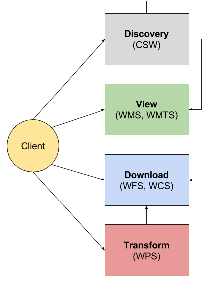
The idea is simple. A user would first use a Discovery service to locate the data of interest. Then they would use a View service for a visual inspection. Once satisfied, a user would eventually use a Download Service to download the data for offline usage, or would use a Transformation service to perform an online spatial analysis.
Discovery services are implemented using CSW (Catalog Services for the Web), which is a protocol designed with a standards-based interface to discover, browse, and query metadata of geospatial data. An interaction with a CSW (e.g., pycsw) typically leads to finding links to other OGC protocols that allow for the viewing and download of the data. GeoNode has a CSW module that allows a client to search for datasets and contents.
View services are implemented using WMS (Web Map Services) and WMTS (Web Map Tile Services), which are the standard HTTP protocols that allow a client to view maps from one or more geospatial databases. The latter are the easiest services to use and understand. They provide a list of maps that can be displayed and combined in a browser application and eventually queried but not modified or changed. You can learn more about WMS in the next sections.
Download services are implemented using WFS (Web Feature Services) and WCS (Web Coverage Services), which are protocols that allow for downloading the source data behind maps, either in vector (WFS) or raster (WCS) formats. Allowing a client to perform the following additional actions during the download:
Spatial filtering (e.g. by bounding box), thus extracting only a certain subset of the data;
Alphanumeric filtering (only
WFS), or extraction by time (WFSandWCS);Selection of attributes of interest (
WFS) or bands (WCS);Changing map projections;
Rescaling (only for
WCS, e.g. allows for a lower resolution version of a raster to be downloaded to save on bandwidth).
Transformation services are used to perform online spatial analysis on vector and raster data. The protocol used in this case is WPS (Web Processing Service).
Common requests in protocol standards
A client makes requests to interact with a service. Each request has a different role, also different services show different calls, but there are a few common points.
Here are common requests and their meaning:
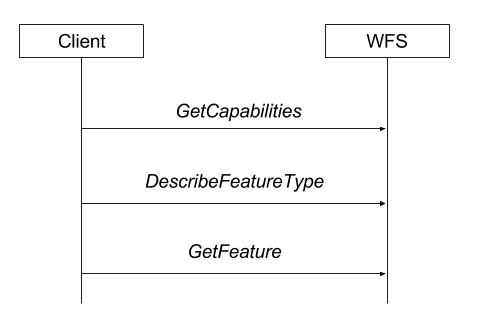
GetCapabilities, this is the only request present in all protocols. It returns a long
XMLdocument describing what the server can do and what the server contains. It allows the client to discover which parts of a protocol are supported (some parts can be optional), which formats are supported in return, and which “subjects” or “contents” are available on the server (these might be maps, vector data, raster data, and so on)Describe< Content >, this is only present in some protocols. It allows a client to get further information about particular content from the server. For example,
DescribeFeatureTypeinWFSprovides the list of attributes for a particular vector dataset, whileDescribeProcessinWPSdescribes the inputs and outputs of a spatial analysis process.Get< Content >, this call retrieves the specified content, normally providing extra parameters to control the production/extraction of the output. For example, we have
GetMapinWMS,GetFeatureinWFS, andGetCoverageinWCS.
These requests are typically performed in sequence by the client. Each one enables the usage of the next one.
Ways to encode requests
Requests in OGC protocols can normally be performed using two different paradigms:
KVP, or Key Value Pair, is a simple URL that supports all the requests parameters as pairs of keys and values in the query string. The
HTTPrequest is aGETin this case. Here is an example of aWFS GetFeatureinKVPmode
  http://demo.geo-solutions.it/geoserver/wfs?
    request=GetFeature&
    version=1.1.0&
    typeName=topp:states&
    propertyName=STATE_NAME,PERSONS&
    BBOX=-75.102613,40.212597,-72.361859,41.512517,EPSG:4326
XML POST contains an
XMLdocument describing the request and is sent to the server as anHTTP POSTrequest. Here is an example of aWFS GetFeatureusingHTTP POSTmode
  <wfs:GetFeature service="WFS" version="1.0.0"
    outputFormat="GML2"
    xmlns:topp="http://www.openplans.org/topp"
    xmlns:wfs="http://www.opengis.net/wfs"
    xmlns:ogc="http://www.opengis.net/ogc"
    xmlns:gml="http://www.opengis.net/gml"
    xmlns:xsi="http://www.w3.org/2001/XMLSchema-instance"
    xsi:schemaLocation="http://www.opengis.net/wfs
                        http://schemas.opengis.net/wfs/1.0.0/WFS-basic.xsd">
    <wfs:Query typeName="topp:states">
      <ogc:PropertyName>topp:STATE_NAME</ogc:PropertyName>
      <ogc:PropertyName>topp:PERSONS</ogc:PropertyName>
      <ogc:Filter>
        <ogc:BBOX>
          <ogc:PropertyName>the_geom</ogc:PropertyName>
          <gml:Box srsName="http://www.opengis.net/gml/srs/epsg.xml#4326">
             <gml:coordinates>-75.102613,40.212597 -72.361859,41.512517</gml:coordinates>
          </gml:Box>
        </ogc:BBOX>
     </ogc:Filter>s
    </wfs:Query>
  </wfs:GetFeature>
GeoNode aims to simplify the process of publishing geospatial content to the server and seamlessly exposing it through the OGC Standard protocols.
In the next section, we will learn how to publish basic geospatial data types into GeoNode.